| diagram | 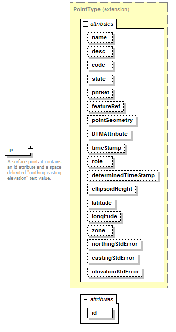 |
||||||||||||||||||||||||||||||||||||||||||||||||||||||||||||||||||||||||||||||||||||||||||||||||||||||||||||||||||||||||
| namespace | http://www.landxml.org/schema/LandXML-1.2 | ||||||||||||||||||||||||||||||||||||||||||||||||||||||||||||||||||||||||||||||||||||||||||||||||||||||||||||||||||||||||
| type | extension of PointType | ||||||||||||||||||||||||||||||||||||||||||||||||||||||||||||||||||||||||||||||||||||||||||||||||||||||||||||||||||||||||
| properties |
|
||||||||||||||||||||||||||||||||||||||||||||||||||||||||||||||||||||||||||||||||||||||||||||||||||||||||||||||||||||||||
| used by |
|
||||||||||||||||||||||||||||||||||||||||||||||||||||||||||||||||||||||||||||||||||||||||||||||||||||||||||||||||||||||||
| facets |
|
||||||||||||||||||||||||||||||||||||||||||||||||||||||||||||||||||||||||||||||||||||||||||||||||||||||||||||||||||||||||
| attributes |
|
||||||||||||||||||||||||||||||||||||||||||||||||||||||||||||||||||||||||||||||||||||||||||||||||||||||||||||||||||||||||
| annotation |
|
||||||||||||||||||||||||||||||||||||||||||||||||||||||||||||||||||||||||||||||||||||||||||||||||||||||||||||||||||||||||
| source | <xs:element name="P"> <xs:annotation> <xs:documentation>A surface point. it contains an id attribute and a space delimited "northing easting elevation" text value.</xs:documentation> <xs:documentation>The id values are referenced by the surface faces for the coordinate values.</xs:documentation> </xs:annotation> <xs:complexType mixed="true"> <xs:simpleContent> <xs:extension base="PointType"> <xs:attribute name="id" type="xs:positiveInteger" use="required"/> </xs:extension> </xs:simpleContent> </xs:complexType> </xs:element> |
attribute P/@id
| type | xs:positiveInteger | ||||
| properties |
|
||||
| source | <xs:attribute name="id" type="xs:positiveInteger" use="required"/> |
XML Schema documentation generated by XMLSpy Schema Editor http://www.altova.com/xmlspy