| diagram | 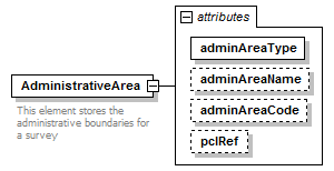 |
||||||||||||||||||||||||||||||
| namespace | http://www.landxml.org/schema/LandXML-1.2 | ||||||||||||||||||||||||||||||
| properties |
|
||||||||||||||||||||||||||||||
| used by |
|
||||||||||||||||||||||||||||||
| attributes |
|
||||||||||||||||||||||||||||||
| annotation |
|
||||||||||||||||||||||||||||||
| source | <xs:element name="AdministrativeArea"> <xs:annotation> <xs:documentation>This element stores the administrative boundaries for a survey</xs:documentation> </xs:annotation> <xs:complexType> <xs:attribute name="adminAreaType" type="adminAreaTypeType" use="required"/> <xs:attribute name="adminAreaName" type="xs:string"/> <xs:attribute name="adminAreaCode" type="xs:string"/> <xs:attribute name="pclRef" type="parcelNameRefs"/> </xs:complexType> </xs:element> |
attribute AdministrativeArea/@adminAreaType
| type | adminAreaTypeType | ||||
| properties |
|
||||
| source | <xs:attribute name="adminAreaType" type="adminAreaTypeType" use="required"/> |
attribute AdministrativeArea/@adminAreaName
| type | xs:string | ||
| properties |
|
||
| source | <xs:attribute name="adminAreaName" type="xs:string"/> |
attribute AdministrativeArea/@adminAreaCode
| type | xs:string | ||
| properties |
|
||
| source | <xs:attribute name="adminAreaCode" type="xs:string"/> |
attribute AdministrativeArea/@pclRef
| type | parcelNameRefs | ||
| properties |
|
||
| source | <xs:attribute name="pclRef" type="parcelNameRefs"/> |
XML Schema documentation generated by XMLSpy Schema Editor http://www.altova.com/xmlspy