| diagram | 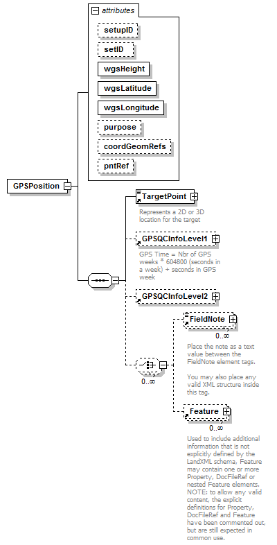 |
||||||||||||||||||||||||||||||||||||||||||||||||||||||
| namespace | http://www.landxml.org/schema/LandXML-1.2 | ||||||||||||||||||||||||||||||||||||||||||||||||||||||
| properties |
|
||||||||||||||||||||||||||||||||||||||||||||||||||||||
| children | TargetPoint GPSQCInfoLevel1 GPSQCInfoLevel2 FieldNote Feature | ||||||||||||||||||||||||||||||||||||||||||||||||||||||
| used by |
|
||||||||||||||||||||||||||||||||||||||||||||||||||||||
| attributes |
|
||||||||||||||||||||||||||||||||||||||||||||||||||||||
| source | <xs:element name="GPSPosition"> <xs:annotation> <xs:documentation/> </xs:annotation> <xs:complexType> <xs:sequence> <xs:element ref="TargetPoint"/> <xs:element ref="GPSQCInfoLevel1" minOccurs="0"/> <xs:element ref="GPSQCInfoLevel2" minOccurs="0"/> <xs:choice minOccurs="0" maxOccurs="unbounded"> <xs:element ref="FieldNote" minOccurs="0" maxOccurs="unbounded"/> <xs:element ref="Feature" minOccurs="0" maxOccurs="unbounded"/> </xs:choice> </xs:sequence> <xs:attribute name="setupID" type="xs:IDREF"/> <xs:attribute name="setID"/> <xs:attribute name="wgsHeight" type="xs:double" use="required"/> <xs:attribute name="wgsLatitude" type="xs:double" use="required"/> <xs:attribute name="wgsLongitude" type="xs:double" use="required"/> <xs:attribute name="purpose"/> <xs:attribute name="coordGeomRefs" type="coordGeomNameRefs"/> <xs:attribute name="pntRef" type="pointNameRef"/> <!-- coordGeomRefs identifies one or more 'name' values that link to specific <Line>, <Curve>, <Spiral> or <IrregularLine> in a <CoordGeom> element. This allows linking an survey observation to specific <Parcel>.<CoordGeom> based geometry. --> </xs:complexType> </xs:element> |
attribute GPSPosition/@setupID
| type | xs:IDREF | ||
| properties |
|
||
| source | <xs:attribute name="setupID" type="xs:IDREF"/> |
attribute GPSPosition/@setID
| properties |
|
||
| source | <xs:attribute name="setID"/> |
attribute GPSPosition/@wgsHeight
| type | xs:double | ||||
| properties |
|
||||
| source | <xs:attribute name="wgsHeight" type="xs:double" use="required"/> |
attribute GPSPosition/@wgsLatitude
| type | xs:double | ||||
| properties |
|
||||
| source | <xs:attribute name="wgsLatitude" type="xs:double" use="required"/> |
attribute GPSPosition/@wgsLongitude
| type | xs:double | ||||
| properties |
|
||||
| source | <xs:attribute name="wgsLongitude" type="xs:double" use="required"/> |
attribute GPSPosition/@purpose
| properties |
|
||
| source | <xs:attribute name="purpose"/> |
attribute GPSPosition/@coordGeomRefs
| type | coordGeomNameRefs | ||
| properties |
|
||
| source | <xs:attribute name="coordGeomRefs" type="coordGeomNameRefs"/> |
attribute GPSPosition/@pntRef
| type | pointNameRef | ||
| properties |
|
||
| source | <xs:attribute name="pntRef" type="pointNameRef"/> |
XML Schema documentation generated by XMLSpy Schema Editor http://www.altova.com/xmlspy